


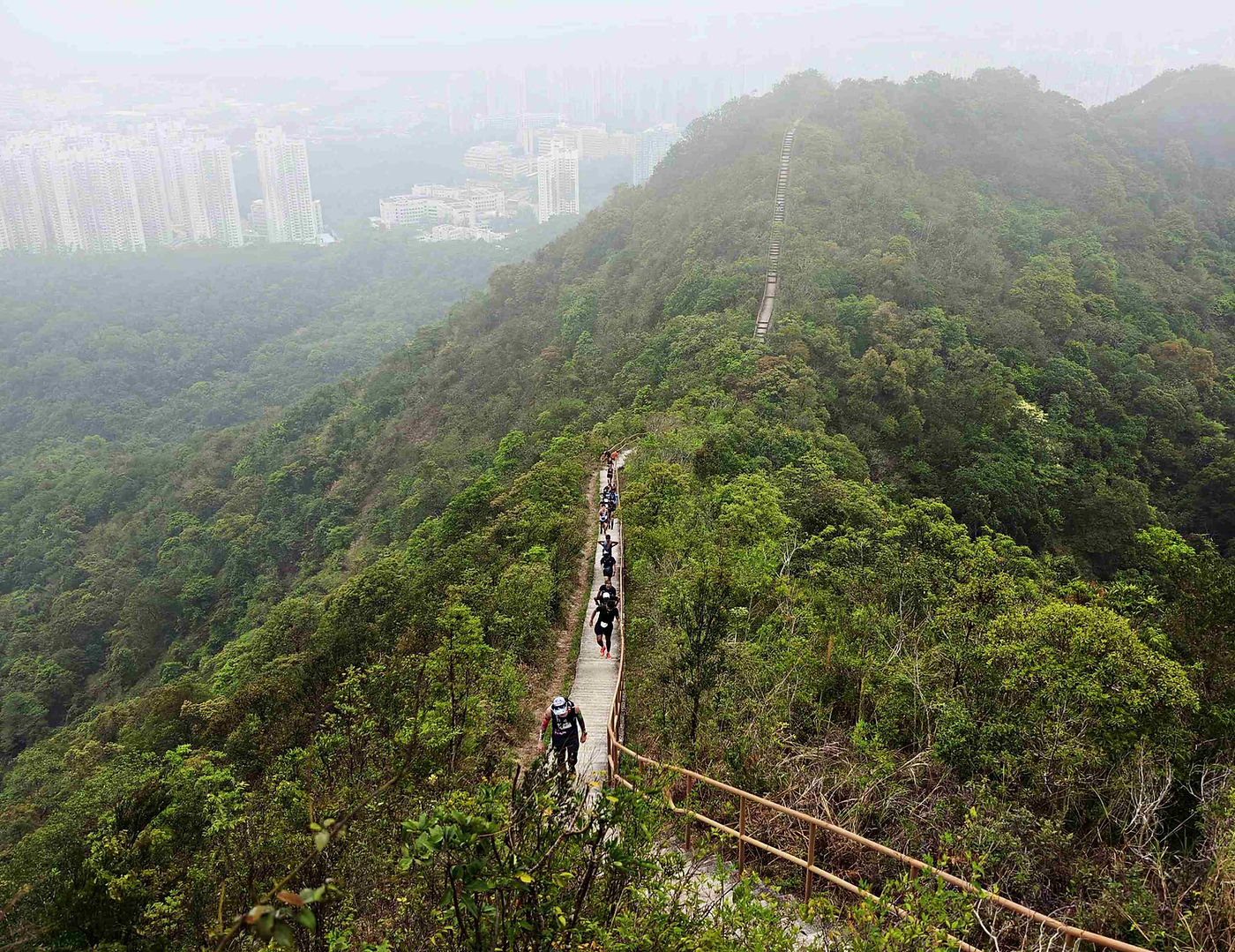


"X" typically symbolises the unknown, infinity, obscurity, and always evokes an intriguing mysterious atmosphere. TRAIL X is centered around Cloudy Hill in the northern New Territories. The TRAIL X course challenges runners to ascend to the 440-metre peak from various directions and passes through famous scenic spots in Pat Sin Leng Country Park, such as Lau Shui Heung, Hok Tau, and Sha Lo Tung.
X 通常象徵著未知、無限、隱晦等意思,總帶有一種吸引人的神秘氣息。TRAIL X 賽事以新界北部九龍坑山為核心,TRAIL X 賽道設計以多方向登上海拔達440米的九龍坑山,途徑八仙嶺郊野公園著名景點如流水響、鶴藪及沙羅洞。
FOLLOW
TRAIL X
Race Name
賽事名稱
Date
日期
Starting time
起步時間
Location
地點
Distance
距離
Registration fee
報名費用
Categories
組別
Trail X
March 21st 2027
2027年3月21日
9:00am
早上9時正
Fung Yuen Playground (65 Ting Kok Road, Tai Po)
鳳園遊樂場 (大埔汀角路65號)
T2 (18km) / T4 (31km)
T2 (18公里) / T4 (31公里)
Early Bird
HKD390 (T2) / HKD490 (T4)
早鳥優惠
港幣$390 (T2) / 港幣$490 (T4)
After early bird
HKD490 (T2) / HKD590 (T4)
早鳥優惠後
港幣$490 (T2) 港幣$590 (T4)
Solo (Men/ Women)
Age: 39 or below, 40-49, 50 or above
個人 (男子/ 女子)
年齡: 39歲或以下, 40-49歲, 50歲或以上
Free bag drop services will be available at the start point on race day
比賽當天,起點將提供免費行李寄放服務
NRNG Loyalty Programme
NRNG 獎賞計劃
Sign up for 4 races out of 8 before the end of November to grab an "I am just a runner" slogan hoodie. Participants will be required to submit a redemption form. The link to the form will be provided at a later date. The deadline for submission is November 30th 2026. Hoodies will be available for collection by the end of December 2026.
Limited quantity, act now!
在11月底前報名參加8場比賽中的任何4場,即可獲得「I am just a runner」標語連帽衛衣衛衣。參賽者需提交電子表格,表格連結稍後提供。提交截止日期為2026年11月30日。連帽衛衣將於2026年12月底前可供領取。
數量有限,立即行動!

"I am just a runner" hoodie
"「I am just a runner」連帽衛衣
Race Courses
賽事路線
T2
Cloudy Hill - 2 climbs
Start /Finish: Fung Yuen Playground
Distance: 18km
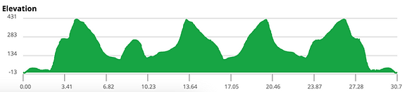
Elevation: 953 D+ | 952m D-
Via: Ting Kok Road, Tung Leung Road, Chuen On Road, Yuk Sau Fung, Cloudy Hill,
Kat Tsai Shan Au, Lau Shui Heung, Hok Tau, Sha Lo Tung, Cloudy Hill,
Yuk Sau Fung, Chuen On Road, Tung Leung Road, Ting Kok Road
Time Limit: 5 hours
九龍坑山 - 2 登
起點 / 終點: 鳳園遊樂場
距離: 18公里
累計攀升: 953米 | 累計下降: 952 米
途徑: 汀角路、棟樑路、全安路、玉秀峰、九龍坑山、
桔仔山坳、流水響、鶴藪、沙羅洞、九龍坑山、
玉秀峰、全安路、棟樑路、汀角路
限時: 5小時

T4
Cloudy Hill - 4 climbs
Start / Finish: Fung Yuen Playground
Distance: 31km
Elevation: 1,571 D+ | 1,572m D-
Via: Ting Kok Road, Tung Leung Road, Chuen On Road, Yuk Sau Fung, Cloudy Hill,
Kat Tsai Shan Au, Lau Shui Heung, Hok Tau, Sha Lo Tung, Cloudy Hill,
Wilson Trail (clockwise), Lau Shui Heung, Kat Tsai Shan Au, Cloudy Hill,
Wilson Trail (reverse), Sha Lo Tung, Hok Tau, Wilson Trail (reverse), Cloudy Hill,
Yuk Sau Fung, Chuen On Road, Tung Leung Road, Ting Kok Road
Time Limit: 8 hours
九龍坑山 - 4 登
起點 / 終點: 鳳園遊樂場
距離: 31公里
累計攀升: 1,571米 | 累計下降: 1,572米
途徑: 汀角路、棟樑路、全安路、玉秀峰、九龍坑山、
桔仔山坳、 流水響、鶴藪、沙羅洞、九龍坑山、
衛奕信徑 (順走)、流水響、桔仔山坳、九龍坑山、
衛奕信徑 (逆走)、沙羅洞、鶴藪、九龍坑山、
玉秀峰、全安路、棟樑路、汀角路
限時: 8小時


About checkpoints
補給站資訊
T2 (18km)

T4 (31km)

Race Pack
選手包
-Race bib
-Japanese-designed race tee
-Red Bull
-NRNG shopping coupon
Collection of race pack
Date: TBA
Place: TBA
-號碼布
-日本設計跑步T恤
-Red Bull
-NRNG 購物券
領取選手包
日期: 稍後公布
地點: 稍後公布


Final design will be updated later
最終設計將會稍後更新

Size Chart
尺碼表

Early Bird Gift
早鳥禮物
- For the first 100 registrants only
-只限首100名參賽者

Final design will be updated later
最終設計將會稍後更新
"I am just a runner " slogan bandana
「I am just a runner」標語頭巾
Finisher Gifts
完賽禮物
-Finisher gift (pick ONE item only: slogan cap, slogan tote bag or ice blanket)
-Finisher medal
-E-cert.
-完賽禮物 (只選一項: 標語跑帽、標語托特包或冰毯)
-完賽獎牌
-電子證書

"I am just a runner" slogan running cap
「I am just a runner」標語跑帽

"I am just a runner" slogan tote bag
「I am just a runner」標語托特包

NRNG X Still On The Way (Japan)
collaboration item.
Final design will be updated later
NRNG X 日本 Still On The Way 聯乘產品
最終設計將會稍後更新


Prizes
獎項
-The top 3 runners in each age category will receive trophies and prizes.
-Fabulous gifts will be announced later。
The overall champions of the men’s and women’s categories in both distances will earn the title of Hill Masters and receive uniquely designed trophies to recognise their outstanding achievements!
-各年齡組別冠亞季軍可獲得獎座及獎品。
-禮物詳情稍後公布。
-男女組別的全場總冠軍為 Hill Master ,獲得獨特設計的獎座,表揚勝出者的卓越成績!
OUR PARTNERS


Sep 27th 2026

Jan 31st 2027

Oct 25th 2026

Feb 21st 2027

No schedule

Dec 6th 2026

Mar 5th-7th 2027
No Schedule

Dec 20th 2026

Mar 21st 2027
NRNG is the organiser of the above races
Please click on the relevant race for more information
NRNG 為賽事的主辦方
請點擊有關賽事以獲得更多資訊
FOLLOW
NRNG